Most people think of Google Maps in terms of getting from point A to point B, but when you throw a little interactivity into the mix, things get a lot more interesting. These clever mashups are especially handy for folks in Victoria, but the majority are equally amusing in other parts of the world.

If you want to:
Find the Best Park for Hiking/Camping/Napping
Check out: BC Parks
In addition to Christy Clark’s somewhat recent announcement about free parking in all of BC’s provincial parks, the province also released a handy online mashup of every park in the province. You can get directions to any protected area and go directly to each park’s website, which makes it a heck of a lot easier to find out about fire bans, campsites, bear/cougar/squirrel sightings or whether or not that last windstorm destroyed the trail. Plus, you might find a new area to explore (Sooke Mountain is a provincial park? Who knew? Well, probably a lot of people, but not me).
Take the Bus Without Being Confused
Check Out: BC Transit
This isn’t breaking news, but for those of you who don’t know, BC Transit is on Google Maps. Simply go to Google Maps, click on Get Directions, enter your start and end points, then click on the bus. Presto! The best part about this is that the map gives you clear walking directions to and from both bus stops, so you’ll never have to wander around, confused and alone, desperately trying to find your friend’s house. Because that’s not a good time.
Find Out if You’ll Actually Have Cell Phone Coverage Before You Invest in a Fancy Phone
Check Out: Open Signal Maps
When I bought my first cell phone, the cell phone dude assured me, “Oh yes! Of course you’ll have cell phone coverage in Cadboro Bay! It’s not as bad as they say.” Lies! In order to use my phone, I had to climb halfway up the hill to UVic, which greatly inconvenienced my social life. If you’re afraid of moving to a dead-zone that either a) has no reception or b) only picks up American signals, check out this cell coverage map that’s a comprehensive database of cell towers and signal strength. It doesn’t detail every part of the city, but it’s neat overview of the best places to carry out phone call without being dropped. And it proves that cell reception in Cadboro Bay is garbage.
See What Your Neighbourhood Looked Like Before It Was Overrun By Condos
Check out: History Pin
This is my new obsession. You can go to any city, Victoria included, and view old photographs posted by both historical societies and regular folks. You can filter the photos by date and even search for particular things, like transportation. It’s like rooting through archives, only minus the dust and the effort. Must-see photos for Victoria are Christ Church Cathedral (1900-1920) and Blanshard St. at Broughton (1930s).
See What People Are Tweeting About (Other Than #YYJ)
Check Out: Trendsmap
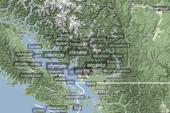
A handy map of real-time tweets in Victoria (and everywhere else in the world). Along with the obvious #YYJ, #YVR and Tuna(?), currently trending are: accident, highway and anxiety. I’m going to take a wild guess and say it has something to do with the car that lost a wheel on Highway 1 this morning and caused traffic to back up to the Millstream overpass. As for “Tuna,” your guess is as good as mine. A case lot sale at Safeway maybe?
Make Yourself Feel Better About Victoria’s Impending Earthquake by Viewing Real-Time Earthquakes Around the World
Check out: Live Earthquake Mashup
The theory behind this (in my mind at least) is that if you overexpose yourself to earthquakes, thinking about Victoria’s “Big One” won’t be so horrifying. Or, this map might just freak you out. Either way, it’s very cool. Zoom out as far as you can and admire the Ring of Fire.


