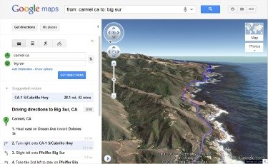
Getting driving directions just got easier, thanks to Google Maps’ latest feature. Helicopter view, known in tech circles as 3D Preview, lets you see your drive from the comfort and safety of a fake chopper. Compared to the 2D, top-down view we’ve become so accustomed to, helicopter view is a more realistic portrayal of how we see the world—horizontally, not vertically.
Getting driving directions just got easier, thanks to Google Maps’ latest feature. Helicopter view, known in tech circles as 3D Preview, lets you see your drive from the comfort and safety of a fake chopper. Compared to the 2D, top-down view we’ve become so accustomed to, helicopter view is a more realistic portrayal of how we see the world—horizontally, not vertically.
 Just enter your starting point and final destination in Google maps as usual then click on the 3D button. To maximize your faux-helicopter experience, press pause and let the map populate itself with roads, 3D buildings and geographical features before taking your ride. The journey moves automatically, but you can stop it at any time to explore the surrounding area. Each phase of the trip is highlighted on the left and you can jump ahead by clicking on any section.
A few blogs have said that helicopter view’s only purpose is to amuse people with its geeky coolness, but I disagree. Strongly. You can use it to find a prettier route, check out neighbourhoods you can’t see from the road or just get a real sense of direction.
If you’re the type of person who doesn’t do well with “drive down Government Street until you see Fisgard, then take a right,” you can pop the route into Google maps and translate it into something that makes sense, visually. Now, you can “drive down Government St until you see the building with the giant 7UP mural on the side, then take your first right. Go through the fancy gate.”
Helicopter view is also great if you want to go for a run or a bike ride. It shows hills, so you won’t have to punish your body more than you want to.
And yes, it’s a good way to waste time. Snoop on everything from the Himalayas (Deadliest Roads style) to the streets of London to your ex-boyfriend’s childhood home (just kidding).
Or, you can check out your own backyard. For a birds-eye view of British Columbia’s greatest drives, check out West Vancouver to Whistler and Sproat Lake to Tofino (just click on the 3D button next to the driving directions). And for all of you transplanted prairie folk (like myself) who’d rather see a patchwork of fields, here is the route from Saskatoon to North Battleford.


